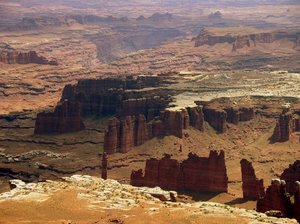
 There is a 100 mile long, unpaved track that circles the Island in the Sky District of Canyonlands National Park, called the White Rim Road. That circuit has become a favorite of mountain bikers, who noticed some years back that it was conveniently located not for from Moab, Utah, which is a popular jumping off point for such activities. But previous to their discovery, and still for all but a few months of the year, the White Rim Road is a largely deserted dirt and slickrock, four-wheel drive track with consistently world-class scenery, and plenty of privacy.
It's also long, slow, bumpy and monotonous driving, when you're not looking at that scenery, but more on that later.
I'm currently hiking and camping in Utah, which explains this off-topic post. I'll continue to cover big news when I'm able to access email, and will also upload and time-phase these entries for posting when I come into town for gas and supplies. To find more of this type of writing based on past trips, look to the folder link at left titled Not Here but There: A Wilderness Journal.
As I took my morning walk today and watched the canyons fill with sunlight and shadow, it occurred to me: If I ever become deaf, I would move to the desert.
Not so surprising, when you think about it. The desert is a place of great stillness, and a place that silence suits well. And after all, sound is the most evanescent of all sensations – here and then gone in an instant, leaving no trace. To be deaf in the desert would be to become more a part of it - a place that displays time and timelessness in its every ancient feature. The events or sensations of an instant – or indeed of a lifetime - don't cut much mustard in such a place as this.
But let me not mislead you: soundless does not equate to lifeless. The desert is a vibrant place, especially at night, as the tracks in the morning sand make clear. Even during the day, any walk through a brushy area will flush cottontails and jackrabbits, the former hopping tentatively away, the latter moving on with greater determination, though both noiselessly. Lizards, large and small, are ever present, and freeze or silently scamper off, depending on what you do. And birds, while scarce, are often in view if you look for them, if not in earshot.
Nor is the desert really silent, actually, though it certainly is in contrast to the rest of the world. So it must especially seem to those that visit the desert briefly in air-conditioned cars to snap a few pictures and then move on. Which is to say almost everyone, including most that move to the rapidly growing cities of the southwest, looking for inexpensive real estate and winter sun, and not for the desert itself.
I'm currently hiking and camping in New Mexico and Utah, which explains this off-topic post. I'll continue to cover big news when I'm able to access email, and will also upload and time-phase these entries for posting when I come into town for gas and supplies. To find more of this type of writing based on past trips, look to the folder link at left titled Not Here but There: A Wilderness Journal.
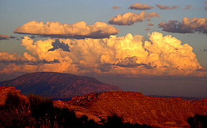 Summer is the time of storms in the deserts of much of the Southwest, just as it is the time of intense heat. Except for its mountainous areas, the Southwest receives most of its meager precipitation in this way. The weather systems that form the thunderstorms of summer are thus vital to the cycle of desert life, and were they ever to fail, so, too, would most of what lives in these dry regions.
There are two essential elements to the weather system that produces these storms. The first is the uneven heating of the desert surface by the sun, which creates variable updrafts that can rise high into the sky. And the second is a summer wind pattern that regularly carries moist air from the Gulf of Mexico into the Southwest – the technically accurate, but rather misleading name given to this element is the "Southwest Monsoon."
When desert updrafts meet this moist Gulf air, they carry it skyward into cooler altitudes, where the moisture condenses into white, decorative cumulus clouds reminiscent of cauliflowers. If the air is sufficiently moist, the clouds can grow in height, becoming "towering cumulus" clouds. And if the updraft is strong, the air more saturated with moisture, and the differential in temperature between warm updraft and cool upper air sufficiently great, then you have all of the necessary elements to create a cumulonimbus cloud - also known as a potential thunderstorm.
I'm currently hiking and camping in New Mexico and Utah, which explains this off-topic post. I'll continue to cover big news when I'm able to access email, and will also upload and time-phase these entries for posting when I come into town for gas and supplies. To find more of this type of writing based on past trips, look to the folder link at left titled Not Here but There: A Wilderness Journal.
 I did not visit the ruins of Kin Bineola the night I arrived nearby, but made camp and turned in instead. August is the month of thunderstorms in the Southwest, and especially in New Mexico. By midafternoon, the anvil shapes of thunderheads were spreading in the four corners of the sky, and not long thereafter grey skirts of rain began their slow descent to the parched earth beneath them. Thunder rumbled richly across the valley, and the sky acquired a rich assemblage of angry grey clouds, towering ivory domes blushed with gold by the setting sun, and a double rainbow arching overall.
I dislike tents. I rarely use them in the Southwest, and revel in the stars above. Usually, there is no rain and never are there any noxious insects to annoy, unless you choose to lay yourself down by the rare, still waters. But this trip, I should have known better and brought one along, as nature has made its habits known here for long enough that I should not have expected it to make an exception just for me.
So there was naught to do but rig my ground sheet up as a rough lean-to against a barbed wire fence, and listen to the pit-pit-patter-pit of rain from dusk to midnight as the occasional thunderstorm struck a glancing blow, scattering droplets via gusty winds as it passed in the night, and illuminating the valley floor in sudden bursts of light as it rumbled by.
I'm currently hiking and camping in Nevada and Utah, which explains this off-topic post. I'll continue to cover big news when I'm able to access email, and will also upload and time-phase these entries for posting when I come into town for gas and supplies. To find more of this type of writing based on past trips, look to the folder link at left titled Not Here but There: A Wilderness Journal.
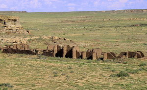
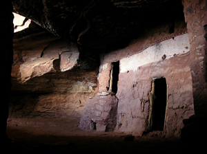
 When you think of spectacular Native American ruins, you're likely to first envision the magnificent cliff houses of Mesa Verde, and their cousins in the Four Corners region of the Southwest. But there are less-well known and equally dramatic sites that can be found near the intersection of Utah, Colorado, Arizona and New Mexico, with the grandest to be found in and near Chaco Canyon.
These buildings were constructed at the same time as the cliff houses, but they are more mysterious. While Mesa Verde and the other cliff ruins in canyons throughout the region were clearly once habitations, the purpose(s) of the "Great Houses" of Chaco Canyon is ambiguous. For example, they contain many rooms, like the cliff houses, and the circular kiva chambers as well. But unlike the cliff dwellings, fireplaces and granaries are very few. If they were dwellings, then, where did they cook? And where did they store their food?
Many archaeologists today therefore believe that the Great Houses of Chaco were not full-time dwellings, but rather some sort of cultural centers, acting as gathering places for a more distributed population. This, despite the great size of the buildings, with hundreds of rooms, and their impressive height - some are as tall as five stories. Indeed, the buildings raised by the Chaco culture were among the largest buildings in the world at their time. And like the cliff dwellings, they were all built – and then abandoned - at roughly the same time.
From time to time I take a break from technology blogging and write about backcountry hiking and camping. This is one such entry, and you can find others at the Not Here but There: a Wilderness Journal.
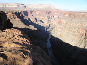 The next day, I walked across a loop of the canyon to watch the sun probe in its depths to find the river, and this time could listened to the twittering of swallows plunging and soaring against the northern wall of the canyon, riding the updraft formed as it warmed in the sun. Again and again, a bird would suddenly wheel and dive, catching a meal as a hapless insect was wafted upwards from the safety of the shadows, and betrayed when its sparkling wings caught the sun.
Along this section of the North Rim, the land for some miles back is protected as a National Park, and therefore off limits to grazing, and protected from resource extraction. Almost all of the few dirt roads that once branched out to stock tanks and corrals are now slowly returning to some semblance of natural vegetation, unlike the land to the north, where only those plants that are sufficiently unappetizing to cattle can thrive.
The single dirt track that branches off the road in from the north leads to the Lava Falls trailhead, which zigzags drops precipitously from the edge of the canyon, and drops rapidly down to the river, a half a mile below. The name of the trail derives from what must have been a spectacular event of only a few thousand years ago, when a lava flow cascaded in a flood of fire over the brink, presumably damning the Colorado far below in a cloud of steam. Over time, the force of the backed up river would have worn the dam away, or perhaps more cataclysmically torn it apart.
From time to time I take a break from technology blogging and write about backcountry hiking and camping. This is one such entry, and you can find others at the Not Here but There: a Wilderness Journal.
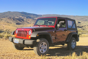
Returning from my first Linux Foundation board meeting ten days ago required a flight change in Las Vegas, and this gave me an excuse to invest a few dollars renting a Jeep Wrangler and a few days exploring northwest Arizona. My favorite pastime is poking around the parts of the US whose maps reveal neither towns, nor even paved roads. This is one of the last such areas I haven't already explored, and it goes by the name of the "Arizona Strip."
 The first part of the name explains itself, given that most of the area lies in Arizona, although in fact the Strip extends up into southern Utah, and a bit west into Nevada as well. The feature that explains its emptiness is the nature of its border to the west and the south: the Grand Canyon – a gulf that along this lengthy stretch has not as yet been (and I hope will never be) violated by a bridge or adjacent highway. In consequence, you can only reach the Strip from the north and east, and only then via one of a small number of dirt roads. For that matter, there's not much to be found to the east, either. Only to the north are there any towns at all.
The emptiness of the Arizona Strip is also due to the fact that it is almost exclusively public land in all of the popular western flavors (National Park, National Monument, State Park, and the balance under the supervision of the Bureau of Land Management). At its greatest extent, the Strip is 150 miles wide, and almost as many again from north to south, and nowhere in that vast expanse can you find a single paved road. No paved roads, and no towns, gas stations or even running water, either – but a great deal of quietly (and often spectacularly) beautiful country can be enjoyed wherever you go.
It had been six long weeks since I returned from a backcountry trip to Utah, and six exhausting weeks at that. Thoroughly drained, it was high time to leave my demons behind (or try to), and seek comfort in the clean fall air of the White Mountains of New Hampshire.
Saturday morning found me not on a trail that would lead to the dramatic viewpoints popular at peak-foliage time, but instead on one that would thread the valleys between the peaks, meander past beaver ponds, and eventually bring me back to my point of departure, suitably (I hoped) refreshed.
The landscape I explored all that day proved to be unexpectedly spectral, haunted by the shadows of countless thousands of dead birches that loomed above a maturing understory of hemlock, spruce and maple. The explanation for their presence was not hard to guess: birch is a "pioneer" species with small, easily wind-borne seeds that sprout into seedlings that not only tolerate, but demand bright sunlight to survive. Throughout the west, aspens are the opportunists that retake the clearings. But in these northeastern woods, it is birch that is most likely to colonize areas burned by fire, or (like this) clearcut by man.
But birch is not a long-lived tree. The thousands of pioneers that together sprouted on these mountainsides a century ago had now together died, their reforesting mission accomplished. In the years that followed, their twigs rotted and dropped, and then their larger branches. Now, like hapless lepers, they raised only blunted limbs to the sky.
 I hadn't thought about it before I reached Utah, but once I neared the border I knew where I wanted to hike first when I arrived. Six years ago, I took a month-long, solo cross-country trip to hike and write in the Southwest. Then, as now, what I wanted to see most was Spirit House.
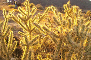 The next morning, the dawn sun shone obliquely through last season's dead grass, igniting the silica in the dried stems, making the dry slope above my campsite gleam like a meadow after an ice storm. The welter of needles worn by Cholla cacti blazed more brightly, as if invested with St. Elmo's Fire rather than simply catching the brilliant light of the rising sun.