 There is a 100 mile long, unpaved track that circles the Island in the Sky District of Canyonlands National Park, called the White Rim Road. That circuit has become a favorite of mountain bikers, who noticed some years back that it was conveniently located not for from Moab, Utah, which is a popular jumping off point for such activities. But previous to their discovery, and still for all but a few months of the year, the White Rim Road is a largely deserted dirt and slickrock, four-wheel drive track with consistently world-class scenery, and plenty of privacy.
It's also long, slow, bumpy and monotonous driving, when you're not looking at that scenery, but more on that later.
The good news for those that like solitude as well as magnificent scenery is that camping is permitted only in the designated campsites – a grand total of 15 on the entire circuit (some are in widely-spaced groups of three; one is a single site). Since it’s too long to drive the White Rim Road as a reasonable day trip, that means the likely population for the 80-odd miles of the circuit that are within the National Park (and the balance as well, in all likelihood) is limited to folks that have a campsite reservation. For the first two days that I was on the road, that number was zero, which rose to a grand total of one for the next two days. But then again, the daytime temperatures reached 102, with surface temperatures higher.
Still, with humidity often at 5% and nights in the sixties or low seventies, it’s quite bearable even in July and August, as long as you expect and prepare for it. Mountain bikers understandably wait for September and October. All the campsites will be filled then, many with parties of maximum size supported by four-wheel drive vehicles carrying their gear, food and (lots of) water.
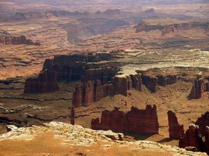
What makes the road both spectacular and tedious at the same time is suggested by its name. The White Rim refers to a massive layer of hard, white sandstone some 25 to 35 feet thick that caps the 150 or more feet of red sandstone that lies beneath. The result is that the layers below the cap erode far more quickly, resulting in a seemingly endless cliff line that rims the mesa, with further plains and canyons continuing downward for as far as the eye can see.
The view inward from the rim is equally impressive. Towering some 2000 feet above you for more than 80 miles of the loop is another mesa, narrow and sinuous, which presents constantly changing, bold profiles, often resembling the gates and walls of an Assyrian fortress, lacking only bas reliefs of muscular lions.
But it is the view outward that is most amazing. Before you stretches an endlessly crenellated maze of dark red canyons, hoodoos, mesas, and sometimes rivers (the Green and the Colorado meet beyond the southern-most point of the circuit), receding into the distance until you can no longer make out their details.
To imagine what the White Rim looks like from the air, think of a maple leaf, with its stem pointed northward. Now imagine that shape morphing before your eyes in fractal fashion, with each pointed lobe – complete with its sub-points – multiplying, until there are a score or so of major projections, and hundreds of minor ones. Each indentation is the result of the runoff of the mesa, collecting in a shallow ravine that terminates there, accelerating the erosion of the caprock at that point. The greater the runoff, the deeper the indentation. If you use Google Earth, you can see it in real (still) life by zooming in here.
The road that circuits the white rim begins just inside the park boundary, and falls down roughly 1300 feet through multiple hairpin turns until it reaches the mesa below. It stays roughly at that level for most of its length, staying outside the smaller mesas that periodically rise on the white rim itself, and generally cuts across the parts of the rim that protrude, staying just inside the deepest in-cuttings of canyons. When it meets them, it skirts massive pouroffs that fall over 100 feet to the next-hardest surface below. At these points, the road travels on bare slickrock. In between it runs largely on red sand and clay.
Perhaps the most fascinating geological features of the White Rim are the hundreds, if not thousands, of hoodoos, towers and needles left behind once the cap rock is no longer there. Most intriguing to me are those that are immediately adjacent to the rim, formed when the cap rock cracks, allowing water to seep through and erode the red sandstone away beneath. The result is hundreds of just joined, or separately standing pillars. The result is a spire with a section of caprock still perched on top. That cap never erodes away entirely. Instead, the red sandstone upon which it rests continues to disappear at a faster rate, until eventually the cap can no longer be supported, and it crashes to the canyon bottom below.
Many of these capped spires resemble enormous bolts, with white heads and red threads. Others resemble solitary sentries, white-turbaned and red robed, perhaps frozen in place by an angry god and condemned to gaze outward for all time, guarding the fortress that is the mesa.
Below these pillars and extending outward are fins of progressively eroding red rock, some extending a short way and resembling the flying buttresses of a cathedral, while others lead out from a hundred yards to a quarter mile, each with its own hoodoos and spires. Depending on the nature of the stone, some of these are sharp and tall, while others look as if they were made from the puddled sand that a child squeezes through her fingers to make spires on the walls of a sand castle.
Between these fins, the cliff drops vertically for perhaps 100 feet, and then for a further fifty as it slopes outward. That slope is composed of blocks, some as large as a small house, that have sheared away from the caprock, and the smaller stuff that has eroded or fallen from the multiple layers of red sandstone above.
The mesa top itself is dry. Further in from the edge, there is a thin red soil, and sometimes sand, with low bushes and grass. In the sand you find the deep tracks of deer, as well as countless delicate impressions of lizards and small rodents, their tracks dusting the surface at dawn until the breeze refills them with grains of sand.
Closer to the edge, the caprock begins to show through, and plant life is restricted to the little islands of sand that collects in shallow depressions. There, the plant life forms miniature Japanese gardens of dwarf trees, grasses and flowers. In the larger areas of soil, you find grass, cactus, agave, flowers, and sometimes low, isolated pinyon pine and juniper. The colors are limited but pleasing: black ravens fly by; the white rock shows through the red soil; and the green vegetation decorates the whole. Occasionally, a small run-off pool creates a tiny oasis.
In many parts of this surrounding skirt of vegetation and stone, the ground is littered with flakes of red jasper, the result of Native Americans working cobbles of that material where they found them. The resulting flakes in most areas range in size from the size of your thumb nail to an inch or two in length, indicating that this is where the raw stone was reduced to pieces of a size and shape (sometimes called performs) that could be easily carried away and later turned into an arrow point, scraper or knife. In some places, you can tell exactly where someone sat hundreds or thousands of years ago, as revealed by the remains of a single cobble deconstructed in front of a comfortable looking boulder or ledge.
The first night I camped at the southern-most tip of the mesa, and saw tens of thousands of tiny pressure flakes scattered everywhere – flakes the size of your little finger to much smaller, and no larger ones at all. Presumably a trail once rose here from below, making this an attractive campsite in ancient as well as in modern times. The thousands of tiny, finishing flakes were the evidence of many years of turning the performs created nearby into finished tools while camping.
The next day, I began to head northwest, and soon the road began to scramble up and over low, intermediate mesas, making the driving more interesting. The central mesa remnant that I had been circling began to move through successive changes, each made dramatic by the fact that most of the great height of this formation seems to be formed by a single layer of much harder red sandstone. Consequently, when the edge of the mesa fails, it shears off in enormous planes, hundreds of feet tall, leaving bold, vertical faces and squared, dramatic corners.
About this time, the road also begins to play tag with the Green River, the down-cutting of which shapes the Western side of the White Rim. But while the Green was 1500 below the White Rim at the latter’s southern most point, it is only a few hundred lower by the time they part company. By that point, the White Rim Road has descended from the mesa surface, and travels by the river itself.
The Green River is well named, at least at this time of year. Its pale green surface mirrors the dramatic scenery that faces it in a dreamy, shimmery way, a green band with soaring red rock formations behind. But while the river is easily visible from any low height, it is completely inaccessible, due to the unbroken walls of willow and tamarisk that bound it on either side, forming impenetrable barricades. These bulwarks may have some benefit, however, as I found my third night of camping. When the sun set behind the high central mesa, the temperature immediately began to fall, eventually to the low 60s. But at the same time, the dense thicket seemed to keep my scent and warmth invisible to any mosquitoes living on the other side of the barrier. Accommodating bats circling overhead picked off any scouts that might otherwise have tipped off the main forces.
At about mile 76, the road leaves the National Park, and continues through BLM land. The pace picks up for awhile on red dirt roads, and then begins to climb once again to the central plateau on a switchbacked road cut into the cliff face. Once it attains the central heights, it makes a straight line to the paved access road that leads to the Park entrance – and there an end.
Now about that driving: If you like backcountry driving (and I do), this isn’t the place to go solely for the experience behind the wheel. Except at the end (going clockwise), there aren’t any long, soft, sandy stretches to shoot, and except for short parts on about a 15 mile stretch on the western side of the circuit, the road isn’t sufficiently challenging to be interesting. But the scenery more than makes up for all the bumping and grinding along the way.
The reason the driving is monotonous is because the road roughly follows the edge of the mesa top. Myriad small runoffs cross it, and scores of major ones. The small runoffs are sudden, abrupt, and hard to see, and you can rarely go more than a few hundred yards without hitting one. So – if you drive more than about 15 or 20 miles an hour, you won’t have time to slow down before your front wheels drop into the ditch, treating you to the sound a moment later of your gear landing in the back with a thundering crash. The major runoffs are easy to see, but more tedious to transit. They are usually bumpy enough to force you down to a crawl.
As a result, while you could manage the circuit in one very long day of 12 hours or so of driving (or less, I suppose, if you wanted to beat your six-ply rental car tires into steel-belted pulp), it would be a rather pointless exercise. Three driving days, though, are just about right, giving you time each day to get a slow start, drive during the hottest part of the day, stop when you want to take pictures or hike, and make camp again so that you can admire the view in a more thorough fashion.
That said, after twelve days in the desert, with temperatures now topping 100, I decided it was time to turn down the thermostat and find a change of scenery. I opened my books of topographic maps and looked for someplace nearby with elevations 7,000 – 8,000 feet (and hence cooler air), no towns, lots of public land, and as few paved roads as possible. Better yet would be none. Much of the far west of Colorado looked like it would meet those requirements nicely. So enough of Utah. Time to head back, a little, east.
For further blog entries on ODF and OOXML, click here
subscribe to the free Consortium Standards Bulletin