From time to time I take a break from technology blogging and write about backcountry hiking and camping. This is one such entry, and you can find others at the Not Here but There: a Wilderness Journal.
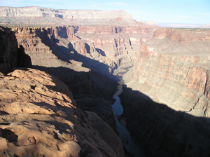 The next day, I walked across a loop of the canyon to watch the sun probe in its depths to find the river, and this time could listened to the twittering of swallows plunging and soaring against the northern wall of the canyon, riding the updraft formed as it warmed in the sun. Again and again, a bird would suddenly wheel and dive, catching a meal as a hapless insect was wafted upwards from the safety of the shadows, and betrayed when its sparkling wings caught the sun.
 Along this section of the North Rim, the land for some miles back is protected as a National Park, and therefore off limits to grazing, and protected from resource extraction. Almost all of the few dirt roads that once branched out to stock tanks and corrals are now slowly returning to some semblance of natural vegetation, unlike the land to the north, where only those plants that are sufficiently unappetizing to cattle can thrive.
The single dirt track that branches off the road in from the north leads to the Lava Falls trailhead, which zigzags drops precipitously from the edge of the canyon, and drops rapidly down to the river, a half a mile below. The name of the trail derives from what must have been a spectacular event of only a few thousand years ago, when a lava flow cascaded in a flood of fire over the brink, presumably damning the Colorado far below in a cloud of steam. Over time, the force of the backed up river would have worn the dam away, or perhaps more cataclysmically torn it apart.
The trail itself did not tempt me – all pain, and no gain, as I could easily see the bankless river from where I already stood. Moreover, the sign at the trailhead provided these helpful pointers for those considering a pleasant day hike down to the Colorado:
-
The trail is poorly marked and has dangerous footing throughout the 1.5 mile descent.
-
Do not make the trip without being fully prepared for self-rescue.
-
This is not a trail for the faint of heart. It is exceptionally steep, exposed and without shade.
-
This route is not recommended when temperatures exceed 80 degrees F.
-
If you begin with a gallon of water or less you will run out.
-
Have a nice day!
Alright, so I made that last bullet up.
Like most trailheads, there was a register hikers are encouraged to use. Unlike most such binders, this one contained log sheets with a different heading for the column traditionally reserved for comments. That heading simply asked, "Did you make it?"
As it happens, not many people appear to have even attempted this trail, much less returned to tell the tale. Here’s a sampling of the remarks left by a few of the 19 parties that tested themsleves against the trail during the preceding four months:
Beautiful!NO! Too dangerousYes; brutalWe made itMade my girlfriend cry [by an Italian hiker]It is true lyer [by his girlfriend]
With great restraint, I decided not to spend the rest of the over 80 degree day descending, and then re-scaling, a mile and a half crumbling grade of cinders steeper than stairs. Instead, I climbed the highest point over looking the canyon, where the view was even more majestic than at the rim below. There, the air was still but not quite silent. Somewhere far away a warbler sang, while from below the murmur of the river was carried faintly along to me by the cool breeze that rose from the canyon.
Too soon, it was time to make the long trek back north. This time, I took a route that carried me across a terrain that was intermittently volcanic. At one place, the plateau across which the lava had spread was divided by a deep valley, the steep sides of which were littered by huge blocks of basalt, split from the edge of the broad lava flow above. Some of the boulders had come to rest erect, staring rough and tall across the valley like Easter Island statues, patiently waiting for some island sculptor to liberate them from the dross confining them.
After the sun set, the sky became a progressively more brilliant yellow as it reached for the horizon, where it made the silhouettes of the mountains razor sharp. To the east, the sky was a nimbus of colors that reached from the horizon high into the sky, suffusing it with a purple haze that, on closer inspection, revealed all of the colors of the rainbow tending from top to bottom, each faint color subtly grading into the next. Half an hour later, the east was dark, and the same gauzy shades now capped the mountains to the west.
Sad to say, my destination for that night was a motel in Overton, Nevada, and for the next morning, the Las Vegas airport. And so here ends my temporary diversion from technology blogging.
But I hope for not too long.
For more selections from Not Here But There: A Wilderness Journal, click here
subscribe to the free Consortium Standards Bulletin